 |
 |
 |
|
Polar
Satellite Precipitation Data Center
|
|
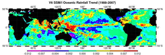
The Polar Satellite Precipitation Data Center The Polar Satellite Precipitation Data Centre (PSPDC) is responsible for the processing, storage, and distribution of oceanic monthly rainfall from data collected by the Special Sensor Microwave Imager (SSM/I) and the Special Sensor Microwave Imager/Sounder (SSMIS) on board the Defense Meteorological Satellite Program (DMSP) satellites. Microwave-based oceanic monthly rain-rates are estimated for the period July 1987 through the present (except December 1987 during which there was insufficient data). Oceanic rain rate products are generated for 2.5° latitude by 2.5° longitude grid boxes between 65° North and 65° South latitude as well as for 5° latitude by 5° longitude grid boxes between 50° North and 50° South.
NASA is working closely in coordination with and providing support to national and international programs such as the U.S. Global Climate Research Program (USGCRP), the International Geosphere-Biosphere Program (IGBP), and the World Climate Research Program (WCRP). The activities at the Polar Satellite Precipitation Centre (PSPDC) represent NASA's contribution to the Global Precipitation Climatology Project (GPCP) of the Global Energy and Water Exchange Experiment (GEWEX), which is sponsored by the World Climate Research Program (WCRP). Members of the PSPDC are also supporting the development of monthly rainfall algorithm for the Tropical Rainfall Measuring Mission (TRMM) using data collected from the Microwave Imager on board the TRMM satellite (the TRMM Microwave Imager, or TMI). Rainfall products developed by the TRMM can be used to cross check the GPCP rainfall products. |
|
Last Update: September 14, 2015
|
|||||
| Research Scientist: Dr. Si Gao, AOES/GMU | |||||
| Please send questions and comments to: Prof. Long S. Chiu |