 |
 |
 |
|
Polar
Satellite Precipitation Data Center
|
|
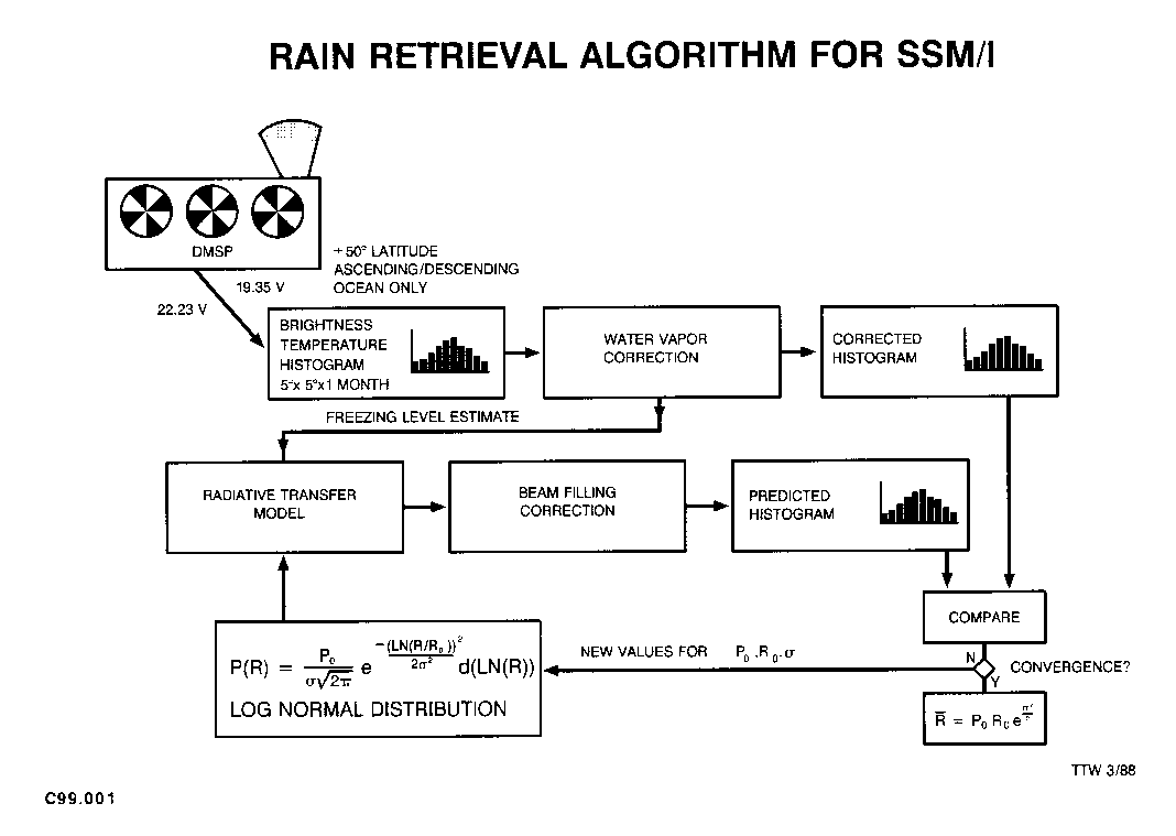
How Do We Estimate Monthly Rainfall? An algorithm for the estimation of monthly rain totals for 5° and 2.5° cells over the oceans from the histograms of SSM/I brightness temperatures has been developed. At microwave frequencies, the ocean is a highly reflective background and the atmosphere is highly transparent under most circumstances. The microwave emission from hydrometeors in the rain column is directly proportional to the rain intensity. Using a model atmosphere we derived a relationship between rainfall rate and a combined brightness temperature of 19 GHz and 22 GHz. This combination reduces the effect of water vapor variability on the rain signal. The freezing height is derived using both the 19 and 22 GHz information. Histogram of the brightness temperature is fitted to a log-normal rain rate distribution via the rain rate-brightness temperature relation. For a detailed description see Wilheit et al., 1991.
How Good Are The Monthly Rainfall Estimates? It is important to estimate the uncertainty in the monthly rainfall products for quantitative hypotheses testing. There are three kinds of error associated with satellite rainfall estimates: systematic, random, and sampling errors. We have compared our monthly rainfall with rain gauge measurements over the Pacific atolls (Morrisey and Greene, 1993). The results show a low bias. Estimates of non-systematic (random and sampling) error was reported by Chang et al. (1993). The overall error is about 55% of the mean, if only am or pm data were used in the estimates. When both a.m. and p.m. data were used, the overall error reduced to about 40% of the mean. |
|
Last Update: September 14, 2015
|
|||||
| Research Scientist: Dr. Si Gao, AOES/GMU | |||||
| Please send questions and comments to: Prof. Long S. Chiu |