|
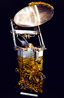
The SSM/I
is a seven-channel, four-frequency (19.35, 22.235, 37, and 85.5 GHz)
conically scanning microwave radiometer. They were built by Hughes Aircraft
Company under the direction of the Air Force Space Division (USAF, SD) and the
Naval Space Systems Activity (NSSA). It represents a joint Air Force/Navy
operational program to obtain synnoptic maps of critical stmospheric,
oceanographic, and selected land parameters on a global scale.
The SSM/I data are processed by the Naval Oceanography Command (NOC) and the Air
Weather Service. The data are sent from NOC to the National Environment
Satellite Data and Information Service (NESDIS) for archival. The data used
in this project are obtained from
Remote Sensing Systems.
The antenna beams scan by continuous rotation with
a period of 1.9 seconds along a conical swath. The incidence angle
at the Earths' surface is about 53°. Earth data are collected
through 102° of the rotation yielding a swath width of 1500
km from the 833 km satellite altitude; calibration data are taken
during the remainder of the rotation. The instrument measures
the radiation in both horizontal and vertical polarizations at
all frequencies except 22.235 GHz where it only measures the vertically
polarized component. The spatial resolution varies from 69x43
km at 19.35 GHz to 15x13 km at 85.5 GHz. The first copy of the
SSM/I was launched in June 1987. Since then SSM/I copies 2 through
6 were launched in December 1990, November 1991, August 1994,
March 1995 and April 1997, respectively.
|
|
 |


