GGS 470 Spring 2020
Remote Sensing of Natural Hazards

Atmosphere
Atmosphere

http://estc.gmu.edu/Course/GGS470-20/

    Course Information
        Title: GGS 470 Remote Sensing of Natural Hazards
        CRN: 17269
        Time:  04:30 pm-7:10 pm, Mondays, 01/21-05/13/20200
        Location: Exploratory Hall 2312
        Instructoris: Prof. John Qu (jqu@gmu.edu)     Teaching Assistant (TA) :  Mr. Bradley Gay(bgay2@gmu.edu)
        Telephone: (703) 993-3958     Office: Room 2412, Exploratory Hall
        Office Hour: Stop by 2:00-4:00PM Mondays and Wednesdays or make appointment

    Course Description

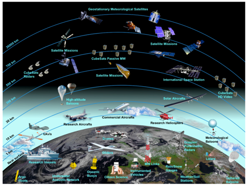
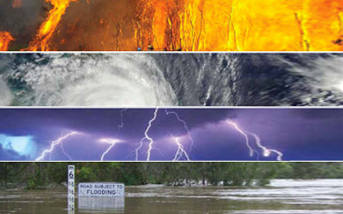
    This course will introduce the students to the fundamental principles of satellite-based applications on natural hazards. One of the main goals of this course is not only to provide the basic knowledge of fundamentals of monitoring natural hazards with satellite remote sensing technology, but also concentrating on observing, tracking and forecasting these events by combining satellite based and in situ observations and model simulations. We will focus on wildfire, drought, flood, cyclonic storms, volcanic eruptions and dust storms, et al.in Spring 2020. Prerequisites

    College Math (such as MATH 214) and physics (such as PHYS 262), or permission of instructor.


    Schedule

    Week one 01/27 Introduction to remote sensing of natural hazards
    Week two 02/03 Physical principles of remote sensing applications of nature hazards
    Week three 02/10 Remote sensing data sources for monitoring natural hazards
    Week four 02/17 Remote sensing of wildfire (1)
    Homework one due
    Week five 02/24 Remote sensing of wildfire (2)
    Week six 03/02 Remote sensing of drought (1)
    Week seven 03/09 Spring Break
    Week eight 03/16 Remote sensing of drought (2) Mid-term
    Week nine 03/23 Remote sensing of dust storms
    Week ten 03/30 Remote sensing of tropical storms and hurricane
    Week eleven 04/06 Remote sensing of flood
    Week twelve 04/13 Invited guest speaker (TBD)
    Homework two due
    Week thirteen 04/20 Open discussions (issues, challenges and future direction of natural hazard monitoring from space) or independent study
    Week fourteen 04/27 Class summary and final project presentations (GGS777, Group 1)
    Week fifteen 05/04 Final project presentations (GGS777 Group 2)
    Week sixteen 05/11 Final term paper due

    Class final project and term paper

    Each student will select one of natural hazards at beginning of the semester and will prepare a literature-reviewing essay to demonstrate of understanding of selected major natural hazards based on the literature reviewing during the semester and will be able to join in-class discussions. Remote sensing application on natural hazards related final presentations and final term papers are encouraged. Final term paper will focus on literature-reviewing, critical thinking and future direction (due May 11).

    Grading
    Grades will be based upon your performance on the homework exercies, midterm, class attendance and final term paper and presentation. The weighted contribution of each of these utems to your final grade is:

  • Homework 30%
  • Midterm 30%
  • Final Project 30%
  • Class Attendence 10%

  •      (A=90-100, B=80-89, C=70-79, D=60-69, F=<60)

    Textbooks
    No Required Textbook.

    Recommended References:

    • Selected “Algorithm Theoretical Basis Document (ATBD)” and selected scientific journal papers will be used during the lectures, which will be posted on Blackboard.